Extending from the shores of Lake Quinsigamond on Worcester’s most Eastern boarder, the trail winds through city park, publicly accessible green space, and city street, taking the hiker across the city to Worcester’s most Western boarder with Paxton and ending at the Cascades.
The trail traverses the Coal Mine Brook, Trinity Woods, Green Hill Park, Grant Square Park, Rural Cemetery, Institute Park, Salisbury Park, Newton Hill at Elm Park, Beaver Brook Park, Hadwen Arboretum, Knights of Columbus Park, Columbus Park, Coes Park, John J. Binienda Memorial Beach, Tetasset Ridge, John W. Spillane Field, Boynton Park, Cascades West, Cascades Park, and Cascading Water.
Trail Overview
Parks & Restrooms
Parking & Bus Stops
Historical points of interest
The East-West Trail traverses 22 publicly accessible green spaces. Together, 14 parks, 5 Greater Worcester Land Trust properties, 2 1 Arboretum (owned by Clark University), 1 public road, and 1 cemetery, create the East-West Trail.
The East-West Trail embodies everything that is great about Worcester: rolling hills, wooded forests, unique neighborhoods, and the urban streetscape.
The Trail (and the City’s character) is largely attributed to the character of its individual parts. Many of the green spaces along the East-West Trail have storied pasts and have long been a part of Worcester’s public landscape. It is our hope that these overviews will inspire you to get outside and check out one of these unique spaces and hike a part of (or maybe the whole 14 miles of) Worcester’s East-West Trail.
The Coal Mine Brook is located along Plantation street and N Lake Ave, and neighbors Lake Quinsigamond. There are technically two parcels of land that comprise this green space – on either side of Plantation Street.
Coal Mine Brook was a fully operational coal mine from 1828 to 1838 fueled by Worcester Industry. It was planned that coal be loaded onto bags and floated down the river to Lake Quinsigamond, but the mine was eventually shut down in 1838 due to flooding. Both parcels are owned by the Greater Worcester Land Trust – the first parcel was acquired in 1998, and the second parcel in 2003.
Trinity Woods is located just north of the Green Hill Golf Course behind the Notre Dame Long Term Care Center.
Trinity Woods was acquired by the Greater Worcester Land Trust in 2011. Trinity Woods is not public use land – it is a restricted conservation area and the East-West Trail skirts its edge.
Click to enlarge
Green Hill Park is Worcester’s largest park at 482.4 acres and it has a storied history. The Adams family, later the Green family, and finally the city of Worcester managed and maintained the land. It was transformed from wooded hills, to farmland, to a country estate, and finally to the public park that we know today.
Green Hill park has numerous resources, both geographic and man made. It contains two ponds, a zoo, a picnic area, a playground, a little league field, basketball courts, an 18-hole golf course, handball courts, a restaurant, a pavilion, and a number of hiking trails. Additionally, the Worcester Parks Department headquarters is also located at Green Hill.
The land that is now Green Hill park was first cleared for settlement over three hundred years ago. Aaron Adams, an Englishman and one of the proprietors of the initial land grant, was one of the first to start managing the landscape.
In 1713, a group of settlers, Aaron Adams of Sudbury, England included, purchased eight square miles from the Massachusetts Bay Colony. Adams eventually acquired 81 acres of land and built the first structure in 1714, establishing a farm on Millstone Hill. Around 1724, 100 acres adjacent to the farm was purchased by the town of Worcester to use as a quarry. In 1754, Dr. Thomas Green purchased 180 acres from Adams. This land and land that was added on at a later date became known as ‘Stormont’ or ‘Green Hill’.
Grant Square is a small park of 1.5 acres is located on Green Hill off from Lincoln Street.
The City of Worcester acquired Grant Square as a gift in 1853. In 2016, the the Green Hill Neighborhood Association celebrated the official reopening of the park at their Annual Community Picnic. In 2015, the city completed stage one of the park’s rehab, installing a state-of-the-art playground, a brand new basketball court, and community garden beds.
Grant Square Park is supported by the Green Hill Neighborhood Association, a member organization of Park Spirit of Worcester, Inc.
Originally spanning 24 acres on the outskirts of town, the Rural Cemetery and Crematory was incorporated by the city of Worcester in 1838. The cemetery features beautifully crafted headstones and mausoleums carved from granite, marble, limestone, and other masonic materials. The Cemetery has curvilinear paths, both paved and dirt, that make walking it fairly simple.
As of 2017 over 13,000 individuals have been put to peace throughout the 40 acres that the cemetery now encompasses. Among the deceased lay many significant individuals from congressmen, mayors, and governors to professional people and war veterans. Construction of a new crematory began in 2016.
Founded as a donation to Worcester Polytechnic Institute (WPI) by Stephen Salisbury III, Institute Park was born in 1887. Salisbury, a great Worcester philanthropist, believed WPI lacked sufficient land for their campus. As time went on, the WPI’s campus expanded into other areas and reduce their need for the park land. Originally the land, specifically Salisbury Pond, was used as a power source for Ichabod Washburn’s thriving wire business.
In 1912 Trustees of the Worcester Art Museum donated 6.4 acres to Institute Park further expanding its presence in Worcester. Many park amenities have been added through the years including: Tennis courts, swings, as well as the Levenson Concert Pavilion, which hosts the Massachusetts Symphony Orchestra for a few nights during the summer.
Salisbury Park is a beautiful 11.8 acres a top of Worcester’s Prospect Hill. The park is named after famous Worcester businessman and philanthropist Stephen Salisbury III.
Salisbury Park features one of Worcester’s most unique attractions, Bancroft Tower. The tower is has medieval qualities and is 56 feet tall, boasting one of the most spectacular city views that Worcester has to offer. Stephen Salisbury III decided to erect the tower in 1900 after the passing of the great Worcester resident George Bancroft. Bancroft was famous politician, statesman, and writer (and the childhood friend of Salisbury III’s father). Among many other accomplishments Bancroft is a founder of the United States Naval Academy and served as the U.S. Minister to Britain.
As city park and public amenity, respectfully, the city of Worcester own Salisbury Park and Bancroft Tower. Park Spirit opens Bancroft Tower to the general public on Sundays in October.
Newton Hill at Elm Park was established when the city of Worcester purchased 61 acres of land, previously privately owned by Colonel John Wetherell and John Sterns. In the 1960s, the City of Worcester took 20-acres of park land to construct Doherty Memorial High School. The City has performed limited maintenance activities at Newton Hill since the early 1900s.
In 2001, the Friends of Newton Hill at Elm Park (FNH) was formed by neighbors in an effort to restore the park for public use and to beautify the space and maintain the trails. FNH has cleared and maintained a network of 6 wooded trails, installed a 18-hold disc-golf course, installed a 12-station fitness circuit, and installed a flagpole at the summit of the hill, among many other accomplishments.
Beaver Brook Park is one of Worcester’s most heavily used parks. This park is the home to Ted Williams Little League and the Worcester Vikings Football program.
Beaver Brook features ball fields, an inline skating rink, two playgrounds, a football field, and walking paths. Many of these amenities were recently redesigned to maximize the park’s usability and minimize injury. Located along Chandler Street across from Foley Stadium, the park is named, of course, for the natural Brook that runs through the park.
The Hadwen Arboretum is located on Lovell and May Streets. Bequeathed to Clark University by Obadiah Hadwen for historical and ecological purposes upon his death in 1907, the University created the interdisciplinary ‘Hadwen Project’ for students to document the various flora.
The Arboretum is home to over 40 different plant species and features several ‘heritage’ trees dating over 100 years old.
The Coal Mine Brook is located along Plantation street and N Lake Ave, and neighbors Lake Quinsigamond. There are technically two parcels of land that comprise this green space – on either side of Plantation Street.
Coal Mine Brook was a fully operational coal mine from 1828 to 1838 fueled by Worcester Industry. It was planned that coal be loaded onto bags and floated down the river to Lake Quinsigamond, but the mine was eventually shut down in 1838 due to flooding. Both parcels are owned by the Greater Worcester Land Trust – the first parcel was acquired in 1998, and the second parcel in 2003.
Formerly known as the Knights of Columbus Property, this is one of Worcester’s newest parks. It features Reed Field, located on the former Knights of Columbus property, a rectangular field for soccer and football, a new playground, and ample parking. It has been a city park since 2005, the new field and other amenities being completed around 2012.
The announcement for the Knights of Columbus Property was made by former Presidential Candidate and Mass Governor Mitt Romney. The Romney administration earmarked $500,000 for the city’s purchase of the seven acres of former Knights of Columbus woodland. That contribution paid for almost half of the $1.7 million dollar pay tag. The rest of the funds from the city, who paid some and also borrowed a bit in block grants to pay for it, and also the Greater Worcester Land Trust donated $145,000.
The Knights of Columbus property is one of the quintuplicate parks that surround Coes Reservoir, the others being Coes Pond Beach, Coes Knife Property, Columbus Park, and the Fenton parcel (the Fenton parcel is a city property but not technically a park).
The Coal Mine Brook is located along Plantation street and N Lake Ave, and neighbors Lake Quinsigamond. There are technically two parcels of land that comprise this green space – on either side of Plantation Street.
Coal Mine Brook was a fully operational coal mine from 1828 to 1838 fueled by Worcester Industry. It was planned that coal be loaded onto bags and floated down the river to Lake Quinsigamond, but the mine was eventually shut down in 1838 due to flooding. Both parcels are owned by the Greater Worcester Land Trust – the first parcel was acquired in 1998, and the second parcel in 2003.
Columbus Park is a small linear park on the back edge of Coe’s Reservoir. It was a gift to the city from the Columbus Park Neighborhood Group in 1935.
This park features hiking trails, scenic views of the pond, and a beach (not supposed to be used for swimming). Swimming is available at Binienda Beach across the pond on Mill Street. You can access Columbus Park from North Circuit Ave off from Lovell Street.
The Coal Mine Brook is located along Plantation street and N Lake Ave, and neighbors Lake Quinsigamond. There are technically two parcels of land that comprise this green space – on either side of Plantation Street.
Coal Mine Brook was a fully operational coal mine from 1828 to 1838 fueled by Worcester Industry. It was planned that coal be loaded onto bags and floated down the river to Lake Quinsigamond, but the mine was eventually shut down in 1838 due to flooding. Both parcels are owned by the Greater Worcester Land Trust – the first parcel was acquired in 1998, and the second parcel in 2003.
This new park was named for the industry that preceded it, as it is located on the site of the former Coe’s Knife Factory, at which the monkey wrench was invented in 1840.
The city acquired the property not too long ago to become park land, since the factory had been long removed. The site features a newly installed bridge connecting Coe’s Knife to Columbus Park, historic Stearns Tavern to be managed on public land by the Seven Hills Foundation, and a new and million dollar multi-generational, all accessible playground.
Formerly known as Coes Pond Beach, the Binienda Memorial Beach is a small park of just under two acres located right along Mill Street.
An acre and a half were taken away from the park in 1962 for the relocation of Mill Street. The beach was filled in and cribs and floats installed in 1929.
The Coal Mine Brook is located along Plantation street and N Lake Ave, and neighbors Lake Quinsigamond. There are technically two parcels of land that comprise this green space – on either side of Plantation Street.
Coal Mine Brook was a fully operational coal mine from 1828 to 1838 fueled by Worcester Industry. It was planned that coal be loaded onto bags and floated down the river to Lake Quinsigamond, but the mine was eventually shut down in 1838 due to flooding. Both parcels are owned by the Greater Worcester Land Trust – the first parcel was acquired in 1998, and the second parcel in 2003.
The CoaTetasset Ridge is a woodsy plot of land located off from Mill Street in Worcester Massachusetts. This area is considered to be one of the best places to hike in Worcester largely because of its natural beauty and folklore associated with the area. If one hikes deeper into Tetasset Ridge they will find themselves located in God’s Acre, a 10 acre section of land that was dedicated to God by Solomon Parsons Jr. in 1840. The folklore associated with this area comes from Solomon Parsons and all the strange events that have taken place in God’s Acre. Tetasset Ridge also connects to Logan Field. The property has been owned by the Greater Worcester Land Trust since 2012.al Mine Brook is located along Plantation street and N Lake Ave, and neighbors Lake Quinsigamond. There are technically two parcels of land that comprise this green space – on either side of Plantation Street.
Coal Mine Brook was a fully operational coal mine from 1828 to 1838 fueled by Worcester Industry. It was planned that coal be loaded onto bags and floated down the river to Lake Quinsigamond, but the mine was eventually shut down in 1838 due to flooding. Both parcels are owned by the Greater Worcester Land Trust – the first parcel was acquired in 1998, and the second parcel in 2003.
Tatnuck Square’s Spillane Field, the former Bailey Prouty Playground, is on land that was originally leased from the Worcester Airport. It was historically operated by Jesse Burkett Little League, which still uses it as a field.
In 2009, Bailey Prouty Playground was revitalized, thanks to a donation from the Spillane Family. In light of that $50,000 donation, the park was renamed John W. Spillane Field. The city also provided $150,000 from the capital budget to fund new fences, landscaping, a new backstop, a scoreboard, safety improvements, and new playground. The late John W. Spillane was a lawyer and businessman from Worcester whose family often used the field.
Boynton Park is Worcester’s most enigmatic park – in the sense that it is a Worcester city park that is located in Paxton. It’s also Worcester’s second largest park at just over 114 acres.
Boynton Park was given to the city as a gift through the will of Charles D. Boynton. Boynton deeded the space to the city for one dollar, under the intentions that it would be used as a park, hospital or sanitarium for the people of Worcester and Paxton. The city actually debated whether or not to accept the gift, as it was thought that it was too far removed from the population to be much use (this is despite the fact that the trolley stop was located 100 yards away from the park entrance).
Boynton Park is unique, forested, public resource that it abuts or is connected by trail to several other municipal parks (Cascades Park) and publicly accessible yet privately owned green space (Cascades West, Cascades East, Cascading Waters, Cooks Pond), to which large maps at Boynton refer to as Worcester’s Northwest Parklands.
Cascades West was acquired by the Greater Worcester Land Trust in 1991 and it features a 3 miles of hiking trails, Kettle Ponds, and the Silver Spring. A stone amphitheater was created here, and it overlooks the Silver Spring and hiking trail of Tetasset Hills.
Accessed from Cataract Street off from Mower Street in the Tatnuck Square area, this park has some really cool history. The park land was once held by George Newton, when the Tatnuck area was a summer community with summer cottages for people looking to escape the city’s industrial center. It was gifted to the city from Newton in 1926. Prior to the role of the Cascades area being a hiking, summer recreation destination, the area was inhabited by Native American tribes. The park features picturesque cascading water (after a good storm), has an amazing network of hiking trails as well as a number of geographic feature, like the enormous boulders at the top of the waterfall area, resulting from glacial activity, and given the name Wunneompset, which means good/beautiful rock.
A Greater Worcester Land Trust property with a conservation restriction since 2005. The trail head to the East-West and the Northwest Parklands trail system and the home of the GWLT caretaker shelter.
Trail signage on Lake Ave North. Click to enlarge.
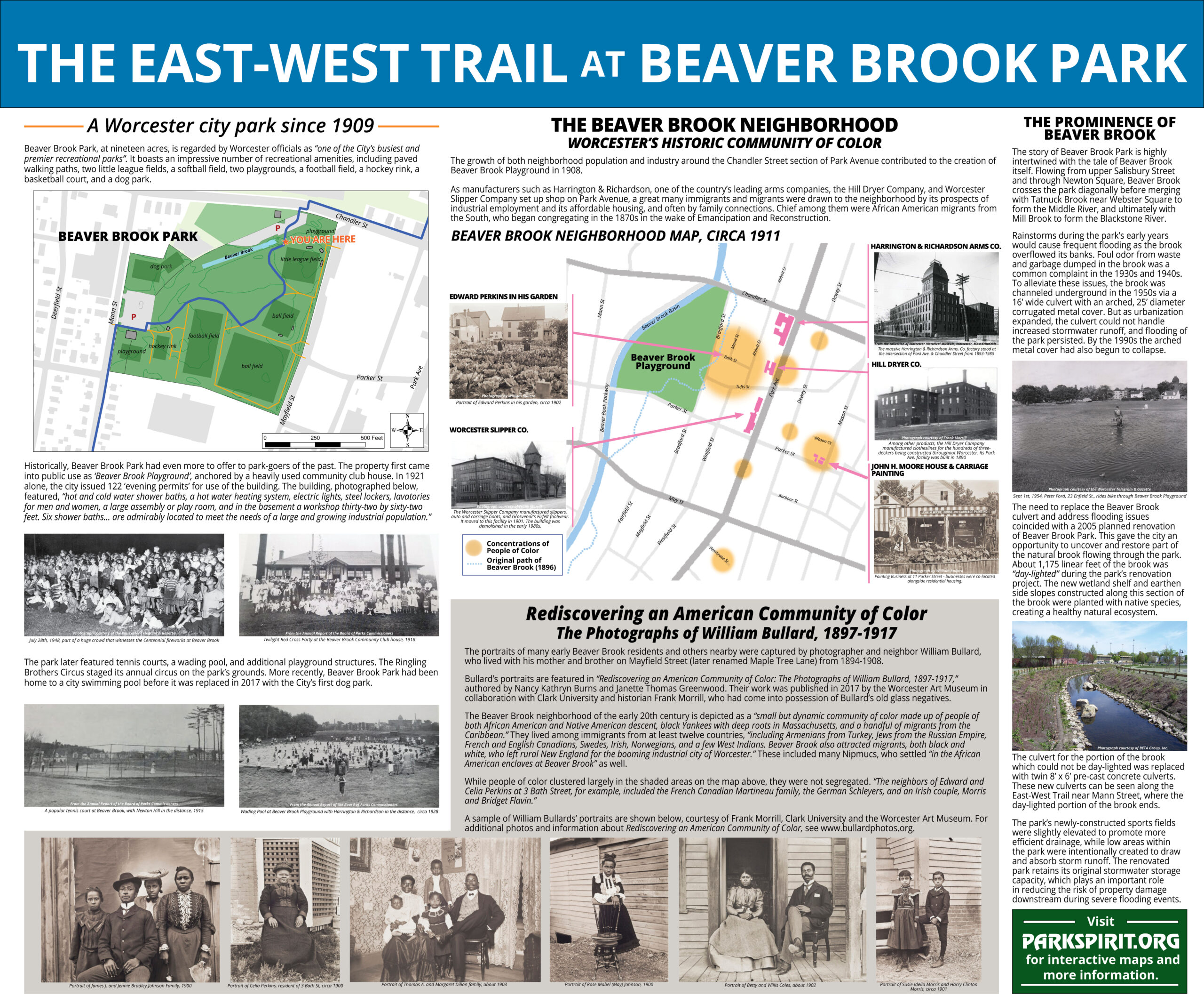
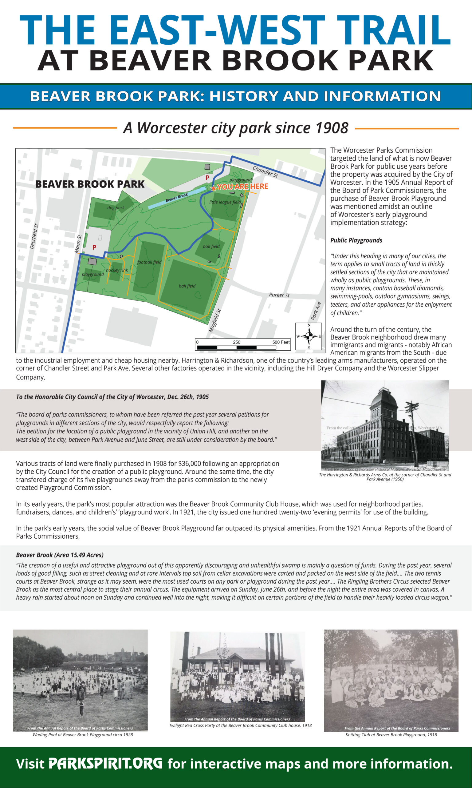
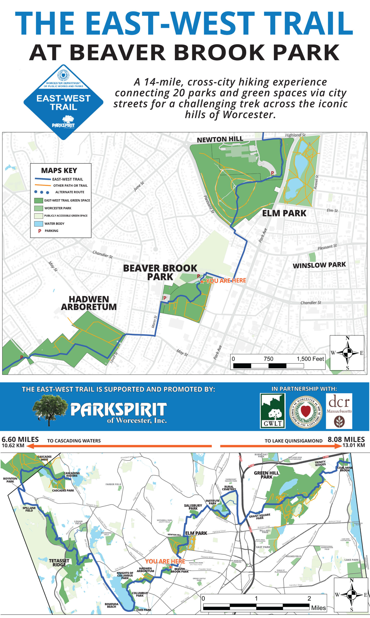
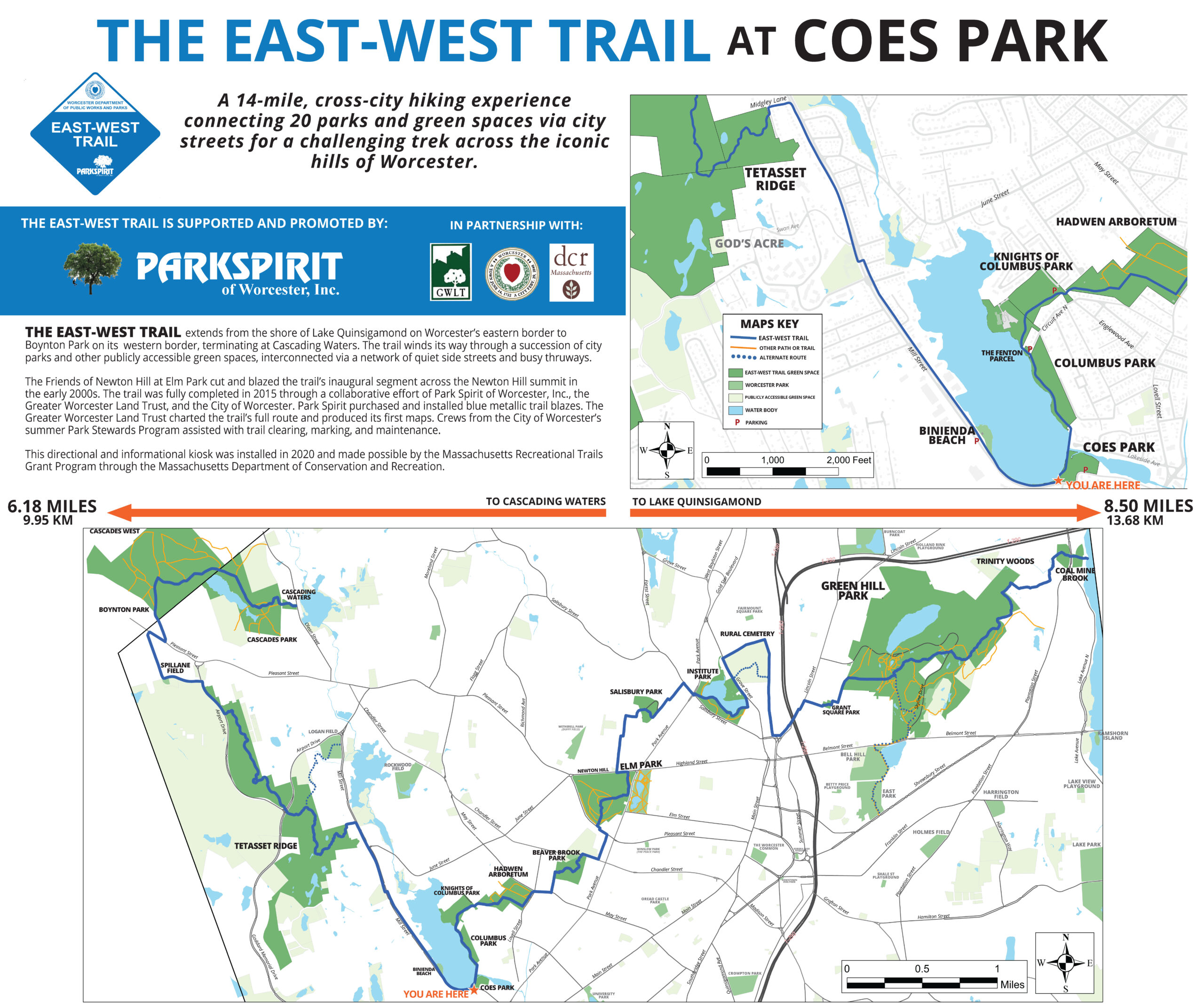
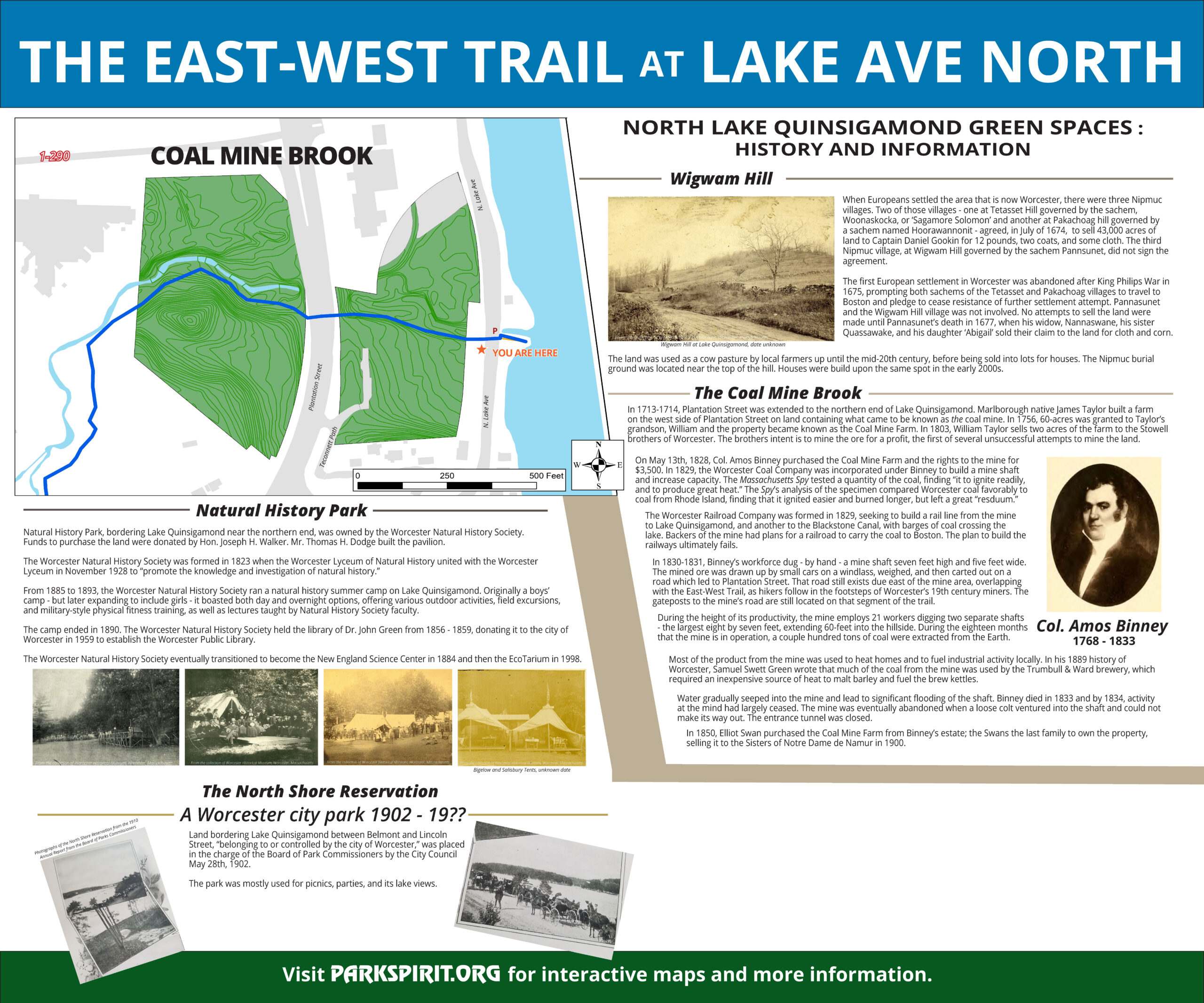
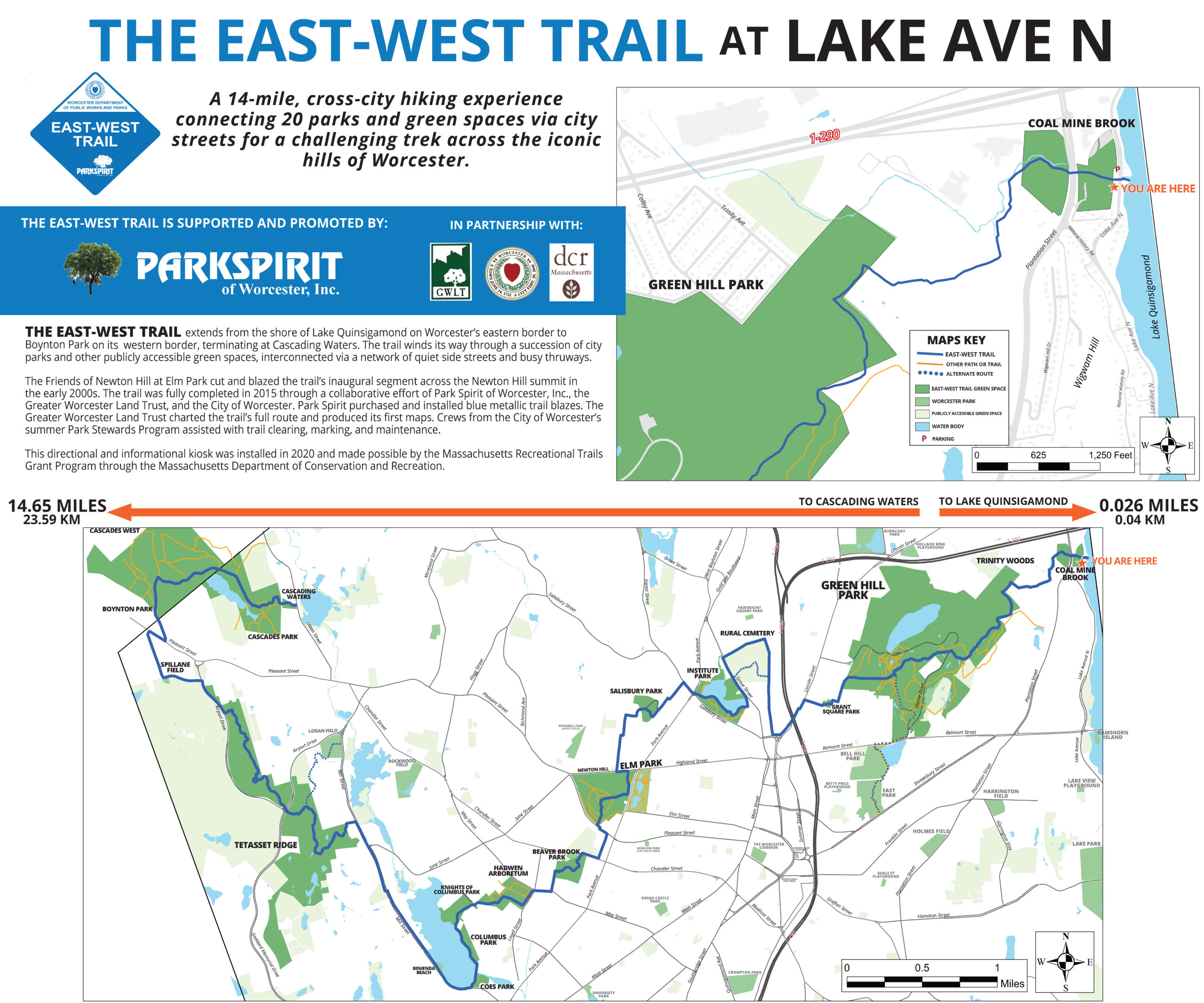
The East-West Trail has been a concept pursued by green space enthusiasts and advocates for many years, and and was taken up most recently by Rick Miller, Park Spirit Board Member and President of the Friends of Newton Hill at Elm Park, and Colin Novick, Executive Director of the Greater Worcester Land Trust.
Miller and Novick began talk about the trail concept around 2001, when the portion of the Trail that cuts through Newton Hill at Elm Park was marked with blue trail blazes. In 2014, Novick produced a map showing how all 20 green spaces would be connected using city streets. In 2015, Novick and Miller presented the Trail concept to Park Spirit’s Board of Directors, which voted unanimously to allocate funds to pay for the trail blazes.
On July 4th, 2015, Miller and his daughter, Brittany Legasey, who at that time served as Director of Communications and Marketing for Park Spirit as well as an advisory board member for the Friends of Newton Hill at Elm Park, hiked the East-West Trail in its entirety.
During the summer of 2015, the City of Worcester donated the labor of one of its Park Stewards Summer Work crews exclusively for the maintenance, clearing, and marking of the East-West Trail. The crew cut an entirely new trail in the wooded area directly below the Worcester Regional Airport and owned by the Greater Worcester Land Trust.
In 2016, the City of Worcester donated the labor of another Park Stewards Summer Work crew for trail maintenance and marking. This crew was responsible for marking the trail’s path over city streets by affixing reflective stickers of the trail blazes on light poles and nailing blazes to city trees. Thanks to the city’s donation, the East-West Trail was officially implemented in August of 2016.
To promote and encourage the use of the East-West Trail (as well as hiking and outdoor activity in Worcester in general), Park Spirit sponsors the ‘Hike the Heart’ campaign, featuring guided hikes at various times during the year. Since the first Hike the Heart Challenge was held in 2016, more than 30 hikes have been held, treating more than 150 hikers to unique outdoor experiences on the East-West Trail and beyond.
In 2017, Park Spirit applied and was selected as a recipient of the Recreational Trails Grant through the Massachusetts Department of Conservation & Recreation.
In 2018, work started on design and purchase of material.
In 2019, five informational kiosk were installed through the help of Holy Cross (Working 4 Worcester project).
– WPI IQP project
– Clark University
– 1st Eagle Scout project – Michael Gates Troop 306 (22 mileage posts & signs)
In 2020, 2nd Eagle Scout project – Conor Synan Troop 6 (5 kiosk signs & 1 mileage post)
3rd Eagle Scout project – AJ Foster Troop 306 (6 kiosk signs)
two park building murals by local artist Eamon Gillen
– Building at Coe’s Pond Beach
– Building at Beaver Brook Park
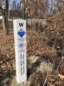
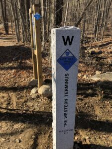
In December 2021, installation of two granite posts at both East and West terminuses.
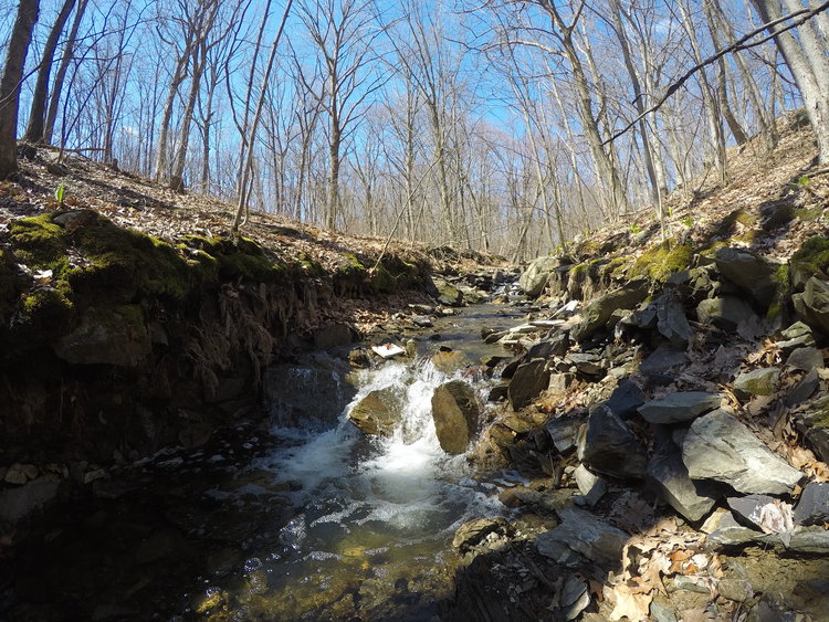
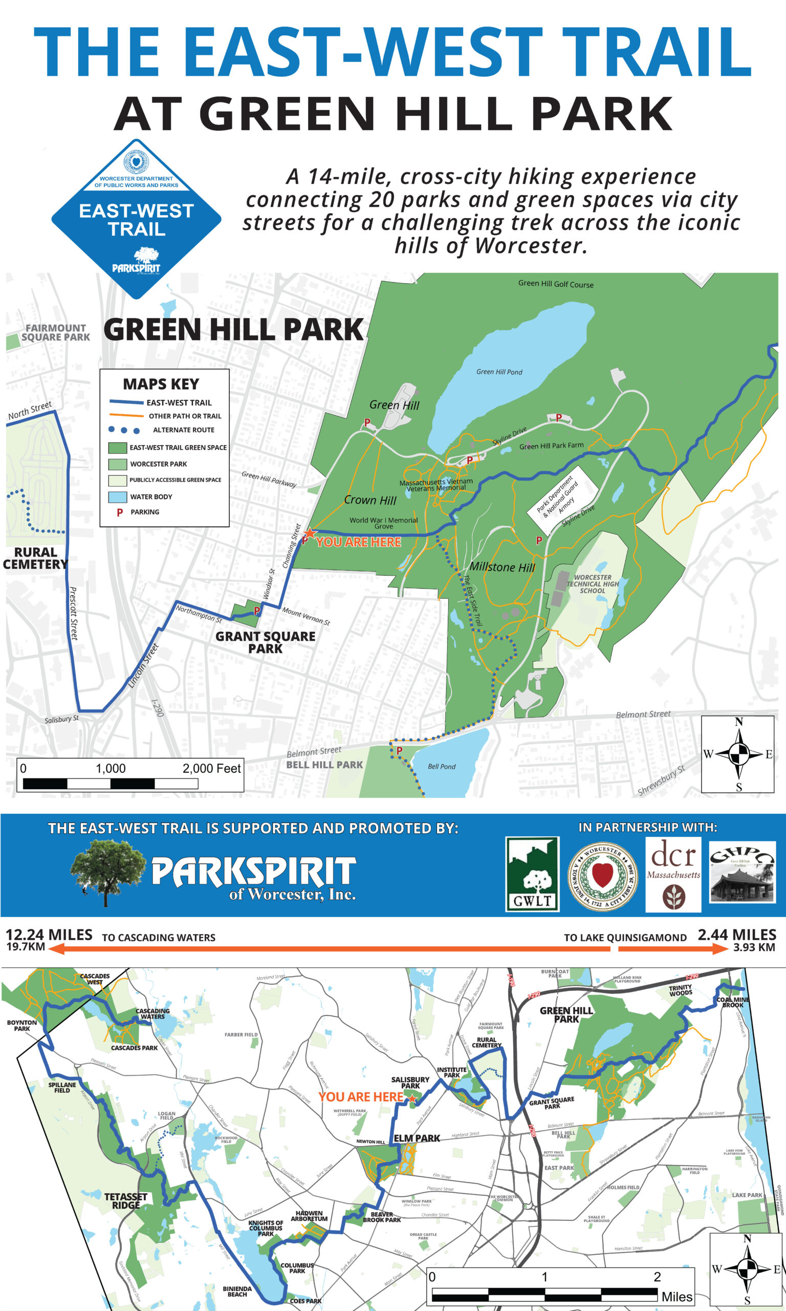
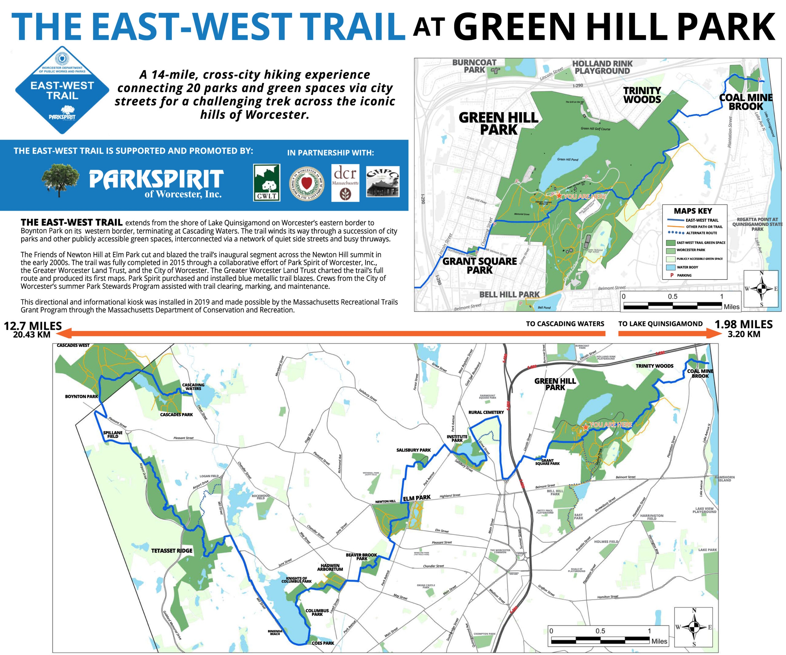
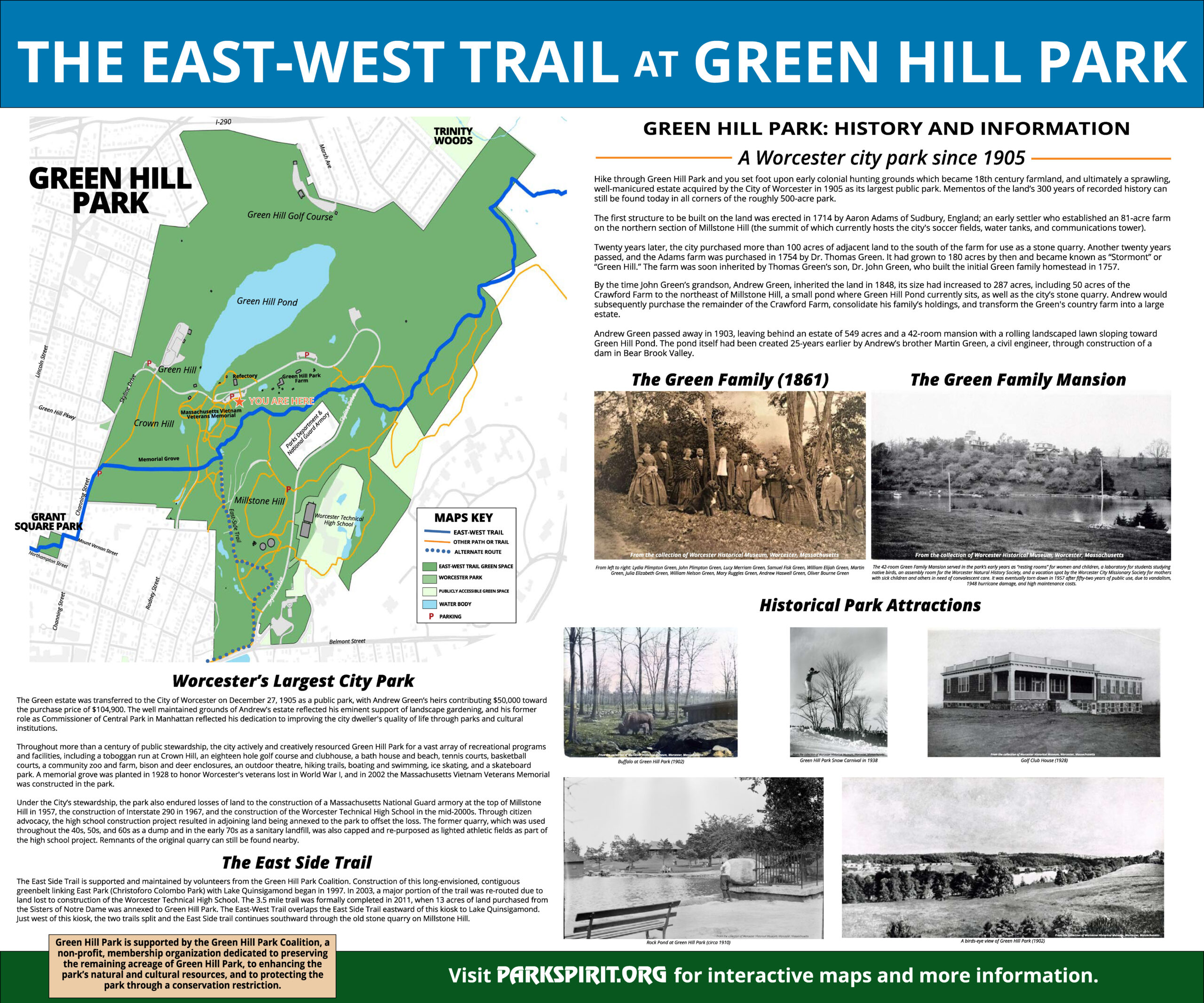
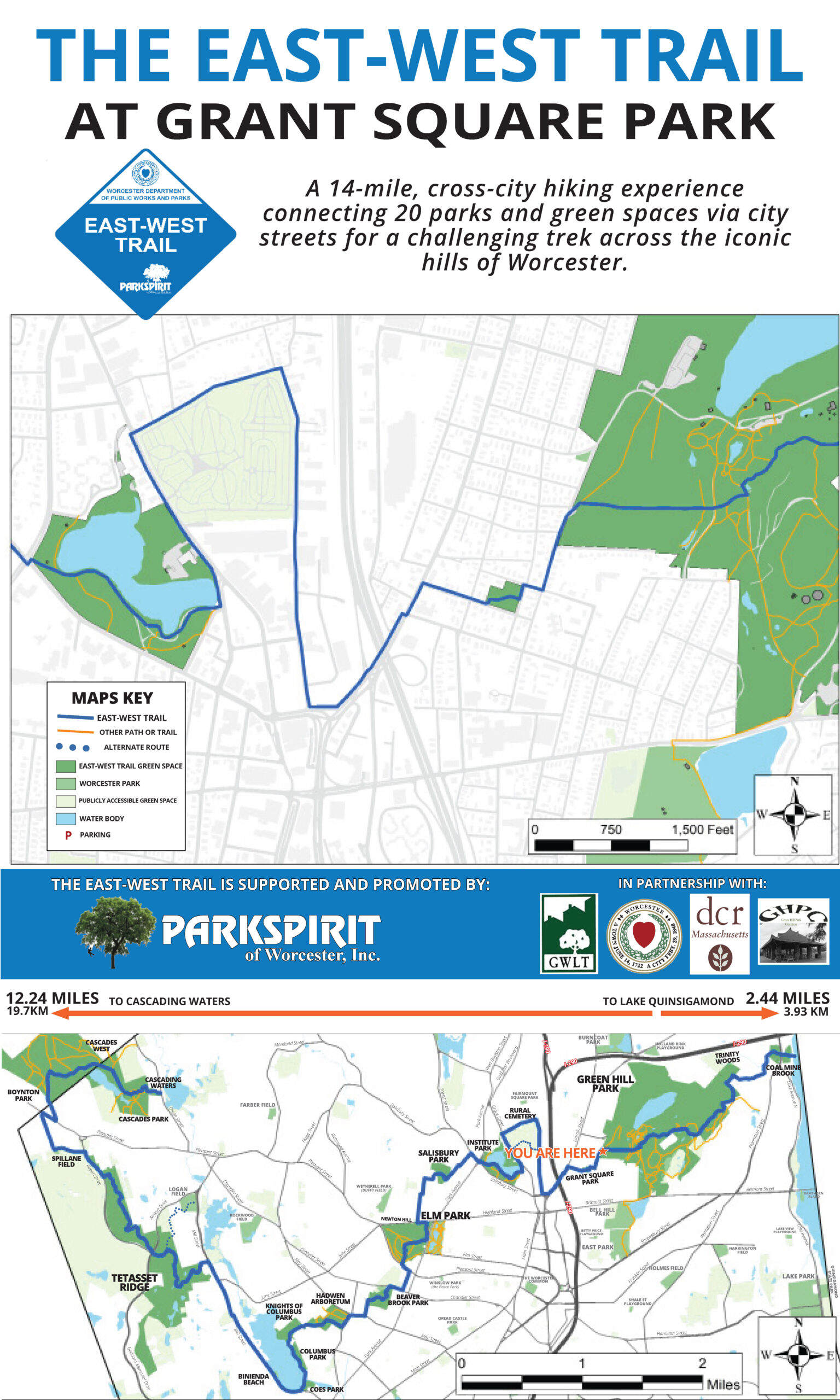
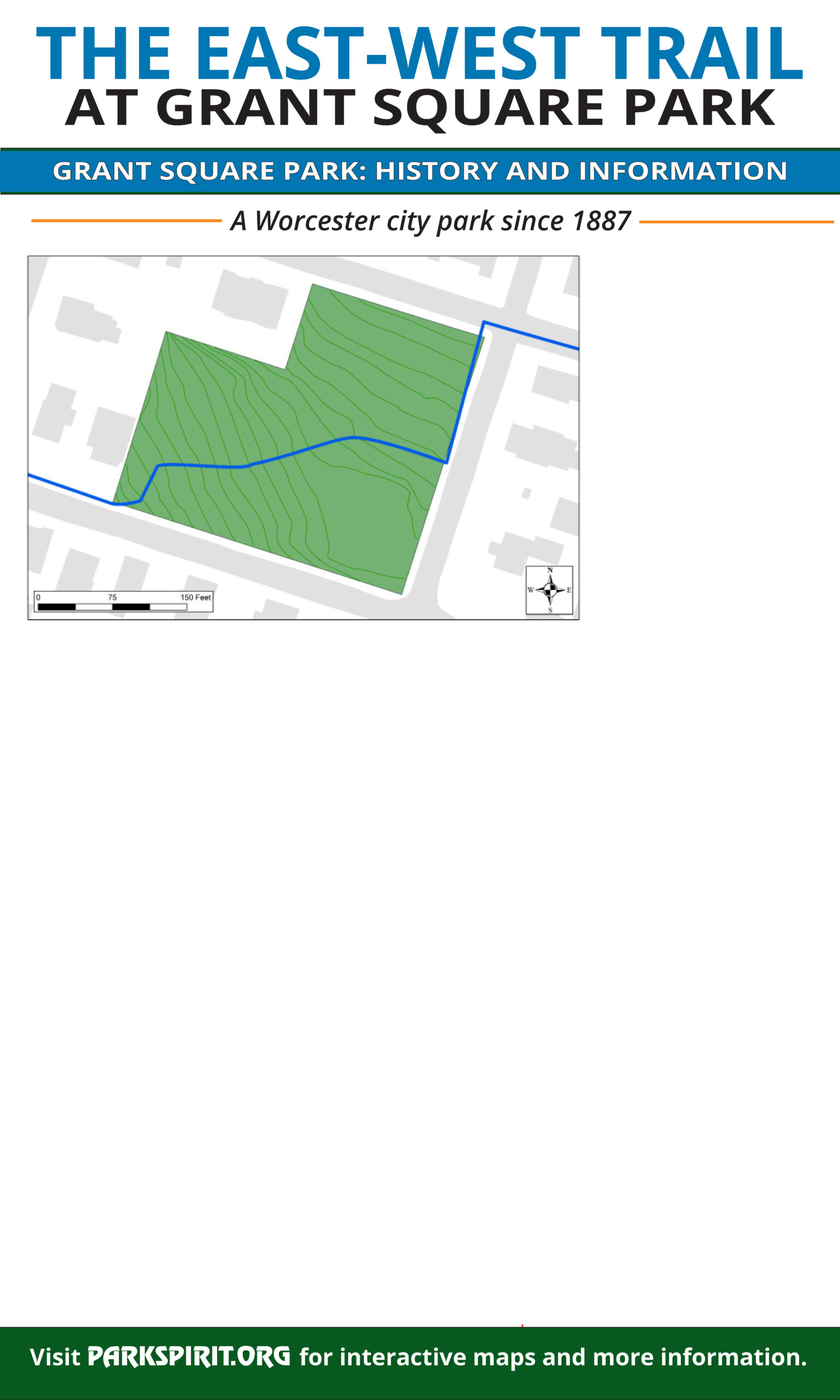
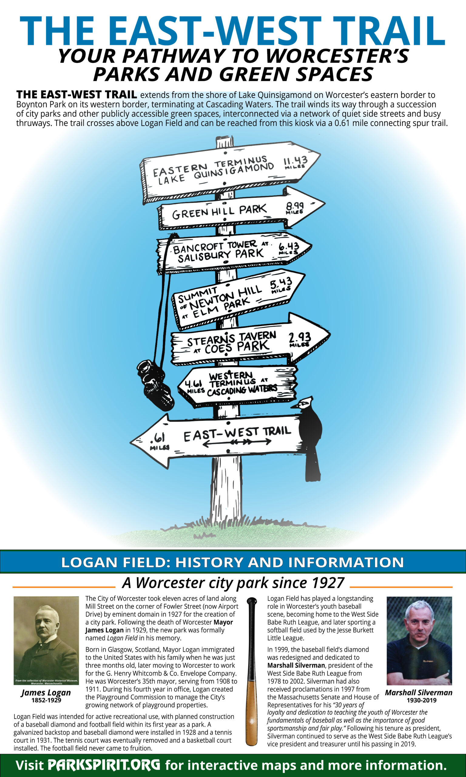
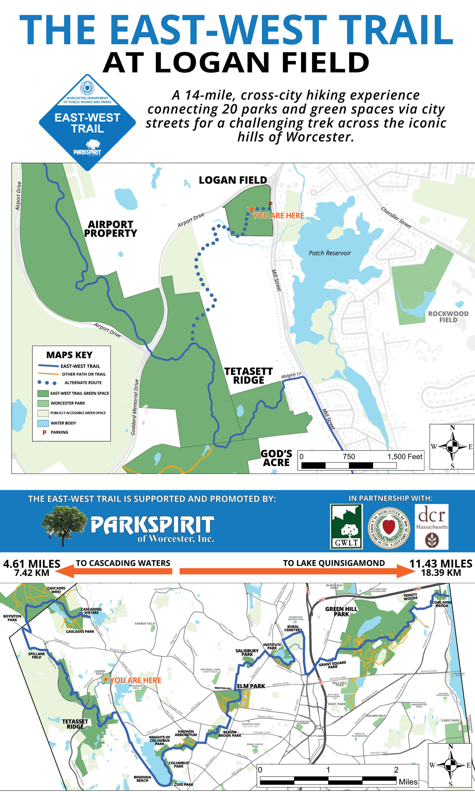
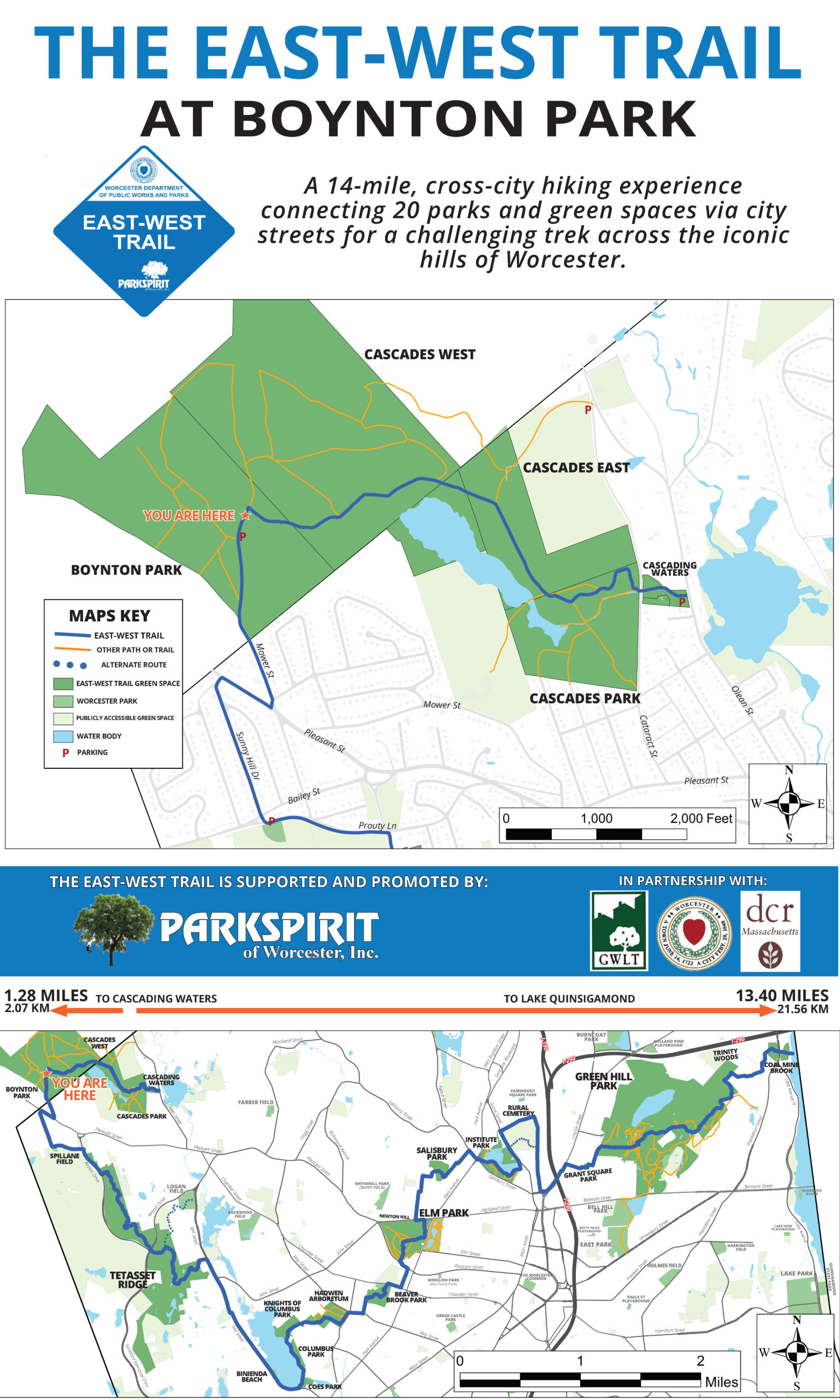
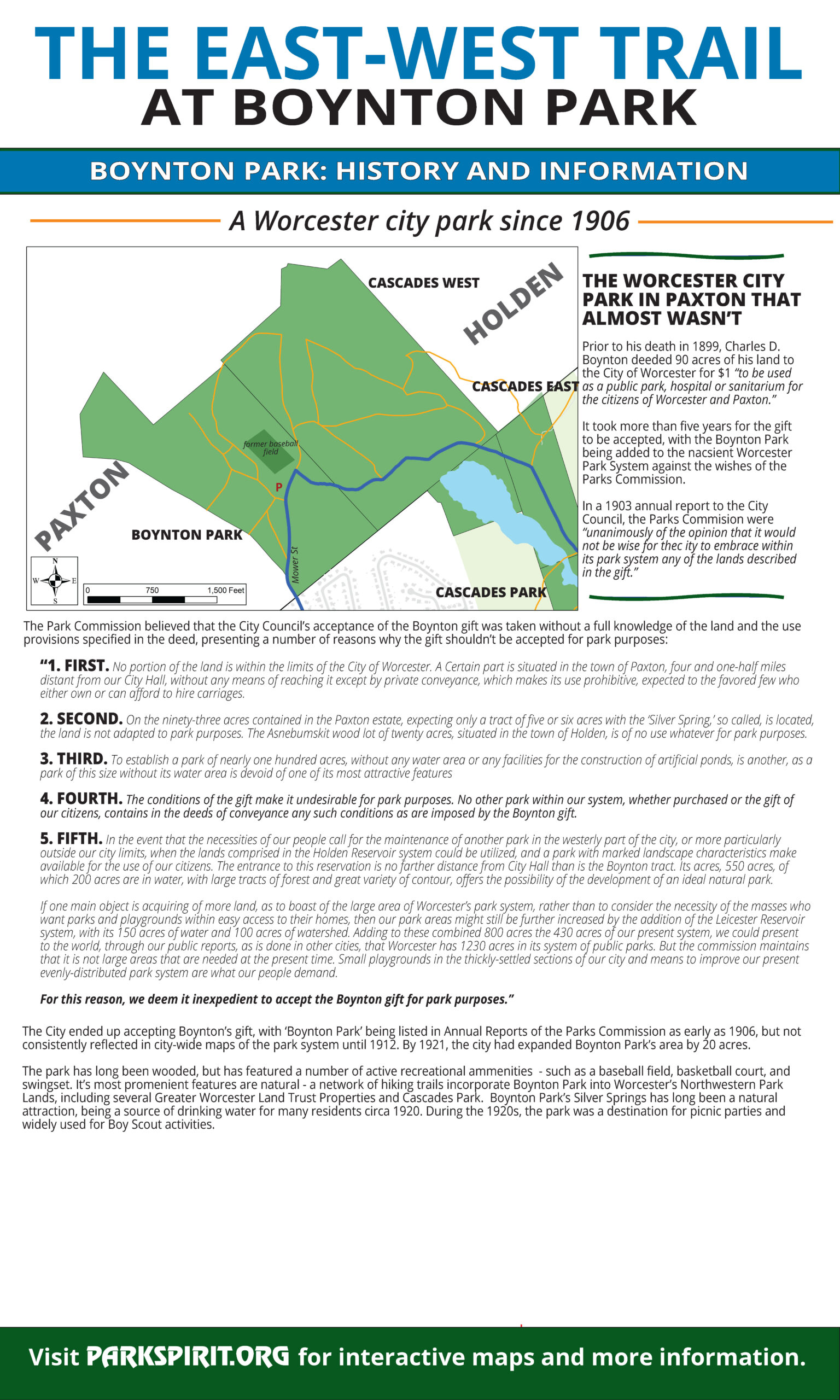
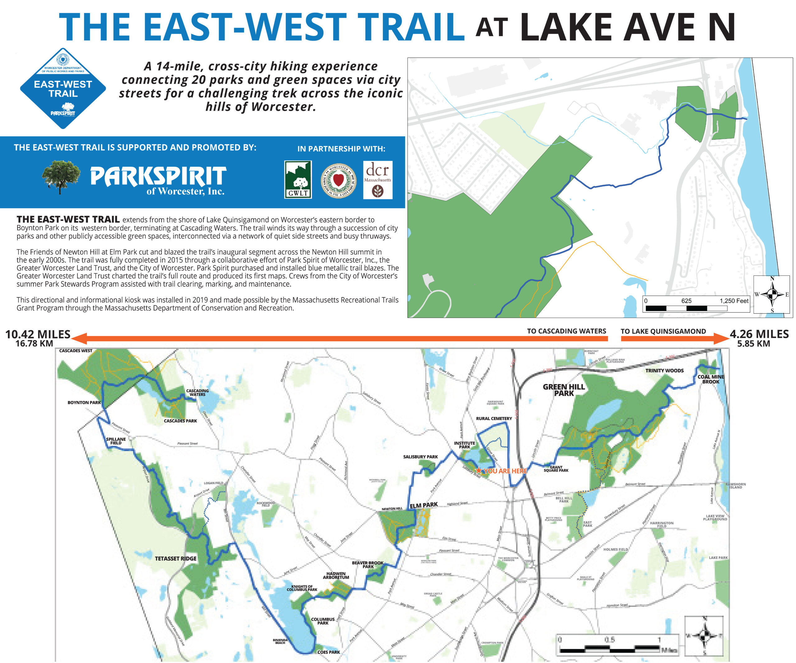
The unveiling of the informational kiosk at Beaver Brook Park celebrates the culmination of Park Spirit’s three-year effort to design, construct, and install informational and directional signage along Worcester’s 14-mile, city-wide East-West hiking trail, made possible with funding from a Recreational Trails Grant through the Massachusetts Department of Conservation and Recreation. Completed with the recent installation of the final kiosk in Beaver Brook Park, the project included; the installation of twenty-three mileage markers posts; sixty-six street signs, 250 trail blazes; twenty-three unique informational and directional kiosks that feature custom designed trail maps and drawings along with historical, cultural, and park history; two building murals to complement trail-wide kiosk maps installed on park buildings; and two granite posts to mark the trail terminuses.
An investment of $49,509 in supplies and volunteer labor, the project began in 2018 through partnership between Park Spirit and the Department of Conservation and Recreation, the Worcester Department of Parks and Recreation, and the Greater Worcester Land Trust and included collaborations with: local colleges Clark University, Worcester Polytechnic Insitute, and the College of Holy Cross; local institutions the Worcester Historical Museum and the Worcester Public Library; and local community groups the Green Hill Park Coalition, the Green Hill Neighborhood Association, the Friends of Newton Hill, the Friends of Institute Park, and the Coes Zone Task Force. Over 1, 250 volunteer hours made the completion of this project possible, including three separate Eagle Scout projects to facilitate the construction and installation of the mileage marker posts and kiosks. The completion of this project gives Worcester’s East-West Trail ‘direction’ and visibility, following the trail’s installation and initial mapping in 2015.
Your contribution makes a real impact in caring for and developing Worcester’s public parks for the betterment of the entire community.